United States Meteorite Impact Craters
Decaturville crater, missouri
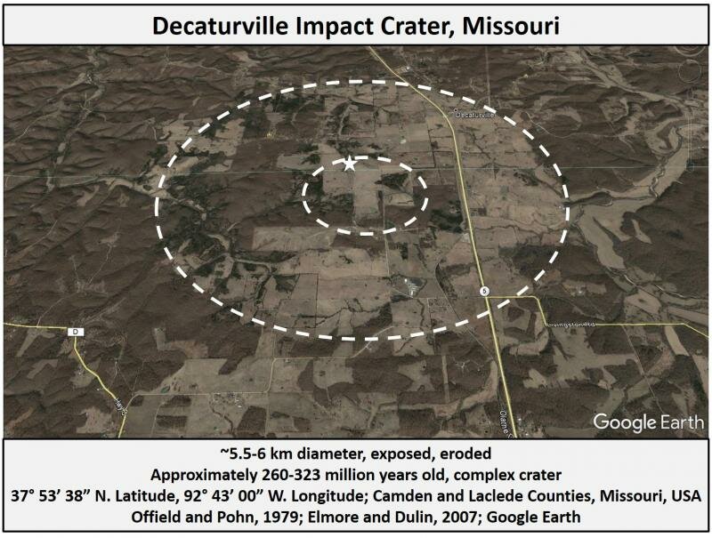
The Decaturville Impact Crater is a 5.5 to 6 km complex crater located in central Missouri at approximately N 37° 54', W 92° 43', about 15 miles south of the town of Camdenton (Offield and Pohn, 1979). The age of the structure is recorded in the Earth Impact Database as less than 300 million years old. Paleomagnetic investigation further constrains the age to the Pennsylvanian to mid Permian. (Elmore and Dulin, 2007) The small white star in the image above indicates the approximate location of the outcrop of uplifted igneous basement rock reported in Offield and Pohn, 1979.
Evidence of Impact Origin
The impact origin of each location listed on this website has been supported by unambiguous diagnostic evidence of hypervelocity impact that has been reported in a scientific (usually peer reviewed) context. Without such evidence, a geological structure is not a confirmed impact crater. This section, which is included for each crater on this website, is not an exhaustive list of such published evidence, but is meant to demonstrate that appropriate work has been done for each listing.
- planar deformation features in quartz (indexed)
- shatter cones
Other significant evidence: very detailed mapping, morphology, drilling, impact melt lithologies, breccia.
Introduction
The first report of anything unusual at the Decaturville site was by Shumard, 1873, who, reporting on the geology of LaClede County, reported an igneous outcrop that produced small quantities of ore. The structure was initially interpreted as volcanic in origin, and an understanding of its impact origins emerged only slowly. The first attribution of the Decaturville structure to an impact seems to have been J. D. Boon and C. C. Albrittton in their 1936 work, 'Meteorite craters and their possible relationship to "cryptovolcanic structures".' Boon and Albritton's suggestions did not convince the scientific community at large, however, and the volcanic vs impact debate lasted several more decades, well into the 1960s. The beginning of a real, quantified, understanding of the structure's impact origins depended on the work of Shoemaker and Eggleton in 1961 and Dietz in 1963.
Between about 1960 and 1965, more or less, the Decaturville structure and the nearby Crooked Creek structure became significant battlefields in a war of paradigms. Prior to this time, impact craters were largely interpreted as volcanic or igneous structures; phreatic explosions, ring dikes, cryptovolcanic, or simply 'cryptoexplosive' features. Through the pioneering work of Dietz and others, and not without opposition, the field of impact crater science emerged from the reinterpretation of existing evidence and from the addition of new and refined petrological and morphological distinctions. Until the sheer mounting weight of evidence bore out in their favor, these scientists received significant argument from equally skilled professionals (eg Amstutz) that held with earlier views. This battle, in large part, is what drove the development of the empirical tool kit of crater science. Unambiguous confirmation of impacts required diagnostic indicators of shock metamorphism. The result of this battle, in the scientific literature, is the suite of techniques we use today in order to differentiate impact craters from objects of similar morphology.
From 1968 to 1970, understanding of the Decaturville structure improved significantly due to its study as a possible analog for the geology of the lunar surface. Initial abstracts of this work were published by Offield and Pohn in 1970 and 1971. In these inital summaries, they firmly established the impact origin for the structure, based on geometry of deformation, which they described in a general sense, and upon evidence of shock metamorphism in several types of minerals. They also made early observations regarding impactite variation, noticing the geographical distribution of monomict vs polymict breccias and noted the presence of remnant bedding in monomict breccias. An in depth summary of their cumulative work, the most detailed yet written for this site, was written by Offield and Pohn, in 1979, under NASA sponsership. A brief summary of early investigations of the site (between 1873 and 1979) are offered on page 2 and 3 of their 1979 report.
The overall morphology of the Decaturville structure is consistent with a complex impact crater with a central uplift. The slightly dished dome of the central uplift, in which rebounded material is raised far above its original position, is surrounded by a large depression. Surrounding this basin is a periferal raised crater rim, which forms an outer circular boundary of the impacted rocks.
Offield and Pohn, 1971, posit erosional removal of about the upper 60 meters of the crater, and suggest that an initial transient cavity, about 2.4 km wide and 600 meters deep, was produced before immediate crater modification partially filled it with megabreccia and very large inwardly flowing blocks from the surrounding crater wall. Offield and Pohn, 1979, also estimate shock pressures, at various depths within the sturcture, based on a variety of different indicators.
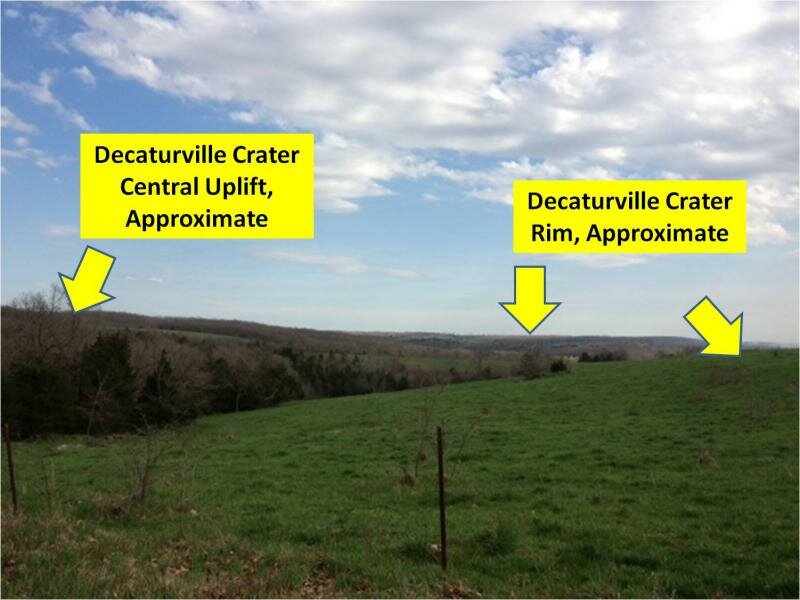
This photo was taken looking back, southeast, from the northwest side of the crater, from road D192. There are very few points within the Decaturville Crater that provide a perspective on the original shape of this ancient and eroded structure. The complexity of the dissected topography hides the more subtle shapes of the rim and central uplift. This point provides somewhat of an exception. The farther ridge to the left is a portion of the central uplift. The distant horizon is approximately the crater rim, and the lowland in between is the annular (ring shaped) basin within the crater.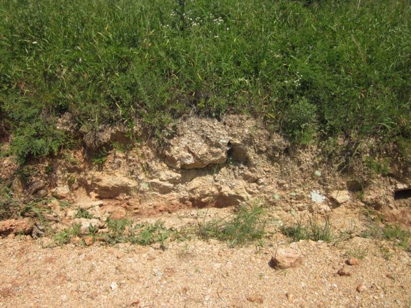 This photo of a cut bank, above a bar ditch, was taken just south of the center of the crater on Livingston road. The rock throughout this area is completely brecciated crater fill.
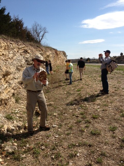
The Highway 5 roadcut on the south rim of the Decaturville Crater is an accessible target for geoscience outings. Hwy 5 cuts through the eastern side of the crater, from north to south. Here, geoscience and space science graduate students from the University of Arkansas stop to examine the rocks of the crater rim. The cut reveals a wide range of features, including intruding and cross-cutting dikes of breccia or melt, violently buckled and fractured rocks, and displaced blocks that are as large as a cargo container. Slickensides, formed during excavation or collapse, are seen on several surfaces. The rocks exposed at this location are Ordovician in age. The small spherules seen in some cherts at this location are not impact spherules. They are ooids formed in the shallow Ordovician sea in which these rocks were deposited. Note: Because all of the bedding planes in the wall are intensely fractured, the wall is unstable, so great caution should be used when approaching it. Overhangs should be studiously avoided, and extreme caution should be used if removing samples from the face. Falling rocks can injure or kill.
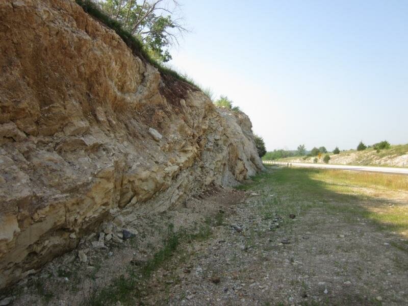
Upturned bedding in the Hwy 5 road cut.
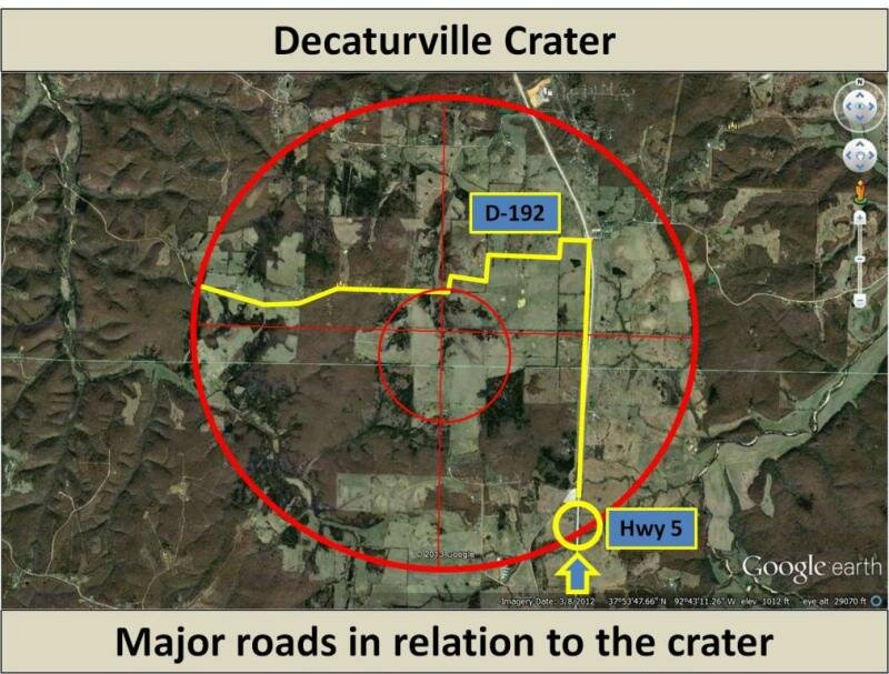
The circle marks the roadcut. It is, to my estimation, about 300 meters inside the actual crater rim, but I could be wrong. Pinpointing the exact location of the rim, beneath topsoil, is difficult, but the road distinctly drops into a basin at about this location. This map is intended to provide a sense of road locations and intersections in relation to crater morphology.
Geological Setting
The Decaturville Impact Structure lies on the Salem Plateau, within the Ozark Plateaus geological province. The surrounding plateau is characterized by very flat bedded carbonates, in marked contrast to the tortured and jumbled stratigraphy of the impacted area.
Coastlines change by thousands of miles over geologic time scales. The region of Missouri in which the Decaturville, Crooked Creek, and Weaubleau structures are found is dominated by carbonate surface rocks. These are marine rock types formed during periods of time when inland seas covered much of central North America. When the earliest of these rocks were deposited, the coastline of North America was located just a few hundred miles south, across the northern third or so of Arkansas.
The deepest known rocks underlying the region are a relatively shallow Cambrian igneous basement that merges, to the north, with the North American continental cratonic mass. This igenous rock was layed down over a billion years ago by volcanic activity that defined the regional landscape of southern Missouri and Northern Arkansas. Tilton et al., 1962, addressed the question of the age of excavated pegmatites near the center of the Decaturville structure (~1.5 billion years old), and found that these are consistent with the underlying Precambrian basement rocks and with related rocks exposed in the St. Francois Mountains at the center of the Ozark uplift. Though only a tiny portion of this rock is exposed by profound rebound uplifting at the center of the Decaturville structure, and none is exposed at Crooked Creek or Weaubleau, all three of these impacts affected this deepest known rock layer.
Offield and Pohn, 1979, report that the depressed basin surrounding the central uplift preserves and exposes several Cambrian to Silurian strata not otherwise exposed in this part of Missouri. They characterize the site as a marine impact, and attribute the minimal surface excavation surrounding the uplift to a profound resurge, or backflow, of excavated and buckled sediment very nearly smoothing the impact surface immediately after the impact and rebound of the central uplift. Evans, in a 2007 abstract, also supports the post impact removal of overlying sediment from the structure.
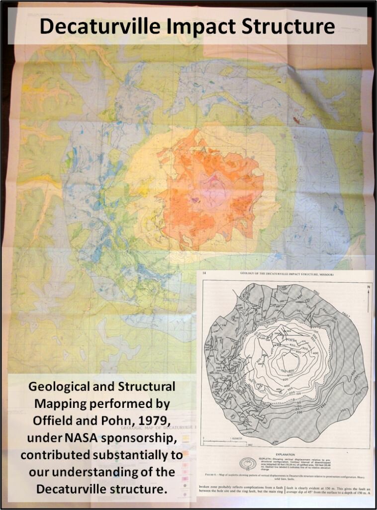
Though the surrounding region is characterized by nearly-flat bedding and what has been referred to as 'layer-cake' geology, the stratigraphic relationships within the disturbed sections of the structure are, to say the least, chaotic. Significant drilling was done on the site (Offield and Pohn, 1979, p.4), and cores are probably stored at Rolla, MO. Examination of these cores and of available outcrops within the crater led to several publications by this pair, in which they, remarkably, untangled the chaos of the annular basin megabreccia (see map in their publication).
The earliest late Cambrian to Ordovician (LaMotte) sandstone is displaced upward by at least 300 meters, and fragments of igneous schists and pegmatites are raised from as deep as 300 to 540 meters (Offield and Pohn, 1979). The disturbed rock sequence is typical of the Pre-Cambrian to Ordovician sequence of the larger Salem Plateau area: A locally pegmatitic igneous precambrian basement (about 1.485 to 1.350 billion years old), related to the rocks exposed at the St. Francois mountains to the east, is overlain by the early Cambrian arkosic Lamotte sandstone, and then by a Cambrian to Ordovician sequence of carbonates, cherts, and sandstones deposited by the repeated transgression of shallow oceans across the area. Between and within the Cambrian to Ordovician rocks and their later successor strata, lie substantial unconformities marking hiatuses (gaps) in deposition, during which shallow seas rolled back for substantial periods, exposing central Missouri to erosion as a continental surface. Above these, the most recent formation, the Jefferson City dolomite, forms the regionally surrounding surface, along with inconsistent remnants of Silurian deposits.
Riis and Evans, in a 2005 abstract, commented on kinematics in the Highway 5 roadcut on the East side of the crater, identifying the exposed rock as Jefferson City Dolomite (lower Ordovician), and placing the outcrop between the bounding normal fault and crater rim. They point out, within this 100 meter section, a radial anticlinal fold, thrust and normal faulting, and breccia associated with the fold and along faults. In an impressive bit of timing reconstruction, they attribute the fold to excavation and the faulting to subsequent modifiation and relaxation stages.
Hydrothermal mineralization at some time subsequent to crater formation is indicated by the presence of abundant iron sulfides in breccias near the central uplift. Amstutz observed these during investigations in the 1960s, along with galena and sphalerite.
Kiilsgaard et al., 1962, in an article about the Crooked Creek area, makes an interesting note regarding oral communication suggesting that there was REE mineralization associated with other mineralization in the brecciated central uplift.
When did the Decaturville impact occur?
Dating impact craters is a challenging process, and doubly so when the impacted rocks are sedimentary carbonates.
Arthur Winslow, while reporting mineable lead and zinc deposits on behalf of the Missouri Geological Survey, in 1894, was the first person to roughly map the Decaturville structure and to attempt to date it. He concluded that the structure had been formed more recently than the Pennsylvanian Period. Other authors made similar attempts in subsequent decades. (Shepard, 1905; Bucher, 1936, etc.) Examination of the stratigraphic context of the impact by Offield and Pohn, 1979, narrowed the timing of the impact to after the beginning of the Pennsylvanian and before the Cretaceous period (about 320 million to about 145 million years ago).
Paleomagnetic dating and stratigraphic interpretation via a cross-cutting relationship were used by Elmore and Dulin, 2007, to further constrain the impact timing to no older than the Early Pennsylvanian and no more recent than the mid-Permian (about 323 million to about 260 million years ago). This work was performed near the outer crater rim. (They also constrained the Weaubleau Osceolla impact.) ()
Riis and Evans, in a 2005 abstract, comment that the presence of mid-Silurian fauna (about 430 million years) provides an additional limit on maximum age.
Miller et al., 2006 and 2007, in a GSA abstract, found Middle to Upper Ordovician (Mohawkian to Cincinnatian) conodonts within the breccias. This indicates that additional sediments, younger than the Jefferson City Dolomite, were once present in the area and have eroded away. This presents an early limit for the impact in the upper Ordovician.
A further attempt was made by Dulin et al., 2011, to date the Decaturville structure by measuring paleomagnetism in new samples from the central uplift. Their abstract presented at the 2011 LPSC indicates research is ongoing, and a refinement may come from the effort.
bibliography and references:
(If links to articles don't work, don't give up. Try pasting the link shown into a search engine or searching for the article authors, title, or other reference information. If your research leads you to additional scientific references related to this crater, please help improve this resource by sending a note with the new citation(s) to: )
Amstutz, G. C. (1965), Tectonic and petrographic observations on polygonal structures in Missouri. Annals of the New York Academy of Sciences, 123:876-894.
(Amstutz argued against an impact origin for Decaturville, instead attributing the '38th parallel lineament' to a significant fault system running east to west across the state of Missouri. In agreement with his contemporaries, he placed Crooked Creek, Avon, Weaubleau, Decaturville, and other structures at intersections. In attributing the complexity of Decaturville structure to multiple generations of faulting, folding, and brecciation, he presaged our later understanding of the stages of crater formation.)
Dulin S. A., Elmore R. D. (2006) Paleomagnetic Constraints on the Age of the Decaturville Impact Structure, Southwest Missouri [abstract #1246], 37th Lunar and Planetary Science Conference.
(2006 abstract superceded by conclusions in Elmore and Dulin, 2007)
Dulin S. A., Elmore R. D., Dennie D. P., Evans S. C., Mulvany P., (2011) Paleomagnetic Investigations of the Decaturville, MO, and Sierra Madera, TX, Impact Structures [abstract #1120], 42nd Lunar and Planetary Science Conference.
(Preliminary report on the paleomagnetic analysis of new samples acquired from within the central uplift region of the crater.)
Elmore R. D., Dulin S. 2007. New paleomagnetic age constraints on the Decaturville impact structure and Weaubleau structure along the 38th parallel in Missouri (North America), Geophys. Res. Lett., 34, L13308, doi:10.1029/2007GL030113.
Evans K. (2004) Weaubleau-Osceola Structure: Carbonate Duck Soup. Impacts in the field 1(4):1-4.
Evans K. R.. 2007. A Tattered Tapestry: Interpreting Remote Sensing Imagery of the Ozark Mountains, 2007 Annual Meeting, Geological Society of America, Abstracts with Programs, Vol. 39, No. 3, p. 64.
(Crooked Creek and Decaturville have both had substantial overlying sediment removed by erosion.)
Evans K. R. (2009) Revisiting the sulfide pit breccia at Decaturville impact structure, Missouri: implications for the age of mineralization (abstract #112-7), Geological Society of America Annual Meeting, Abstracts with Program, Volume 41, No. 7, p. 314.
Evans K. R., Davis G. H., Fultz T. L., Miller J. F., Thomas D. B. (2009) Decaturville structure, central Missouri: evidence for a pre-Devonian marine impact? (abstract #13-12) Geological Society of America South-Central Section Meeting, Abstracts with Programs, Volume 41, No. 2, p. 30.
Evans K. R., Mulvany P. S., Miller J. F., Mickus K. L. and Davis G. H. (2005) SEPM research conference: The sedimentary record of meteorite impacts, Springfield, Missouri, May 21-23, 2005 - field trips guidebook. 54 p.
-
Field Trip 1: Weaubleau Osceola
-
Field Trip 2: Decaturville and Crooked Creek
no link found
Grieve, R. A. F., Masaitis, V. L., The economic potential of terrestrial impact craters. International Geology Review, v. 36, pp. 105-151. 1994.
Krishnaswamy, D. S., Amstutz, H. C., Geology of the Decaturville disturbance in Missouri (abstract). Geological Society of America, Bulletin, v. 71, p. 1910. 1960.
no link found
Luczaj, J. 1998. Argument supporting explosive igneous activity for the origin of “cryptoexplosion” structures in the midcontinent, United States. Geology. v.26:295-298.
Miller J. F., Evans K. R., Kurtz V. R., Thompson T. L., Mulvaney P. S., Sandberg C. A., Repetski J. E., Ethington R. L. 2006. Using Conodonts and Other Fossils to Determine the Age of Missouri's 38th Parallel Structures and Some "Lost Horizons" of the Ozark Dome. (abstract)2006 Geological Society of America Philadelphia Annual Meeting, Abstracts with Programs, Vol 38, No. 7, p 184.
(This abstract, which concentrates primarily on the Weaubleau, briefly mentions that the authors have found Decaturville fallback breccia containing Mohawkian and Cincinnatian, Middle to Upper Ordovician condonts. They suggest that these are redeposited from disrupted rock, and that the younger material at the location has been removed by erosion.)
Miller, J.F., Evans, K.R., Ethington, R.L., Repetski, J.E., Sandberg, C.A., and Thompson, T.L., 2007, Critical stratigraphic data from reworked conodonts in impact breccias across Missouris Ozark dome: 2007 Geological Society of America South-Central and North-Central Joint Section Meeting, Abstracts with Programs, v. 39(3), p. 62.
(Conodont analysis in breccias from all 3 Missouri impact structures. Although the uppermost portions of the breccias at the Decaturville crater, as well as any overlying sediments,have been removed by subsequent erosion, the authors make a significant discovery in identifying Upper Ordovician conodonts within the breccias.)
Offield, T. W., Pohn, H.A. and Naeser, C.W., The character and origin of the Decaturville, Missouri cryptoexplosion structure (abstract). Geological Society of America, Abstracts with Programs, v. 2, p. 639. 1970
no link found
Offield, T. W., Pohn, H. A., Style and sequence of deformation at the Decaturville, Missouri impact structure (abstract). Meteoritics, v. 6, pp. 296-297. 1971
(Most of the information is preliminary to and contained within their later substantive works from '77 and '79. The authors report on crater size prior to and subsequent to modification, estimate the amount of erosional removal of rock, mention substantive geometric (morphological) and shock metamorphic evidence for impact origin, describe variation in the suite of impactites observed, and give a rough overview of faulting and other displacement in terms of the craters development and final disposition, all encompassed in only about 3 times as many words as are here used to describe the abstract.)
Offield, T. W., Pohn, H. A., Deformation at the Decaturville impact structure, Missouri. Roddy, D.J., Pepin, R.O. and Merrill, R.B., eds., Impact and Explosion Cratering, Pergamon Press, New York, pp. 321-341. 1977.
Offield, T.W., and Pohn, H.A., 1979, Geology of the Decaturville impact structure, Missouri: U.S. Geological Survey Professional Paper 1042, 48 pp.
(This is a key text.)
Rampino M. R., Glikson A., Koeberl C., Reimold W. U., and Luczaj J. 1999. Argument supporting explosive igneous activity for the origin of “cryptoexplosion” structures in the midcontinent, United States: Comments and ReplyGeology, v.27:279-285.
Riis, R.H., and Evans, K.R., 2005, Kinematic analysis of roadcuts in the Decaturville structure, central Missouri: Transactions of the Missouri Academy of Sciences 39.
(Hwy 5 roadcut is identified as Jefferson City and is placed in context (between bounding normal fault and rim). A radial fold, accomodating compression during excavation, is exposed in cross section, as is subsequent faulting formed during modification and settling. Each is pointed out along with associated breccias. A nice look at a beautiful cross section of geologic compensations to impact stress in a context that is as visible as any museum display.)
Snyder, F. G., Gerdemann, P. E., Explosive igneous activity along an Illinois-Missouri-Kansas axis. American Journal of Science, v. 263, pp. 465-493. 1965.
Snyder, F. G., Beveridge, T. R., Gerdemann, P. E., Hendriks, H. E., Fellows, L., 1964, Cryptovolcanic structures of south central Missouri. Guidebook, Eleventh Annual Field Trip of the Association of Missouri Geologists, 11 p.
Tarr, W. A., The origin of the Decaturville dome in Camden County, Missouri (abstract). Missouri Academy of Sciences, Proceedings, v. 1, pp. 99-101. 1935.
no link found
(1962), Mineral Ages from the Wichita and Arbuckle Mountains, Oklahoma, and the St. Francis Mountains, Missouri, J. Geophys. Res., 67(10), 40114019, doi:10.1029/JZ067i010p04011.
Zimmerman, R. A., Amstutz, G. C., 1965. The polygonal structure at Decaturville, Missouri - new tectonic observations. Neues Jahrbuch fur Mineralogie Monatshefte, v. 9, pp. 288-307.
no link found
Zimmermann, R. A., Amstutz, G. C., The Decaturville sulfide breccia - a Cambro-Ordovician mud volcanoe. Chemie der Erde, v. 17, pp. 253-274. 1972.
no link found
R. A. Zimmermann, A. C. Spreng. 1984. The Sulfide-Bearing Sedimentary Dikes and Strata of Lower Ordovician Dolomites, Decaturville, Missouri, U.S.A. in Syngenesis and Epigenesis in the Formation of Mineral Deposits in Sedimentary and Diagenetic Features. eds: Wauschkuhn A., Cornelia Kluth C., and Zimmermann R. A. Springer Berlin Heidelberg. pp. 350-372.