United States Meteorite Impact Craters
Impact craters and possible impact craters in the ozarks region of the united states
There are currently (2015) only 185 known and confirmed meteorite impact craters on the planet earth. The Ozarks region, a relatively small section of the United States spanning primarily Northwest Arkansas and Southern and Central Missouri, contains 2 of these impact craters, Decaturville and Crooked Creek. In addition to these, a probable impact structure, the Weaubleau, or Weaubleau-Osceola, and several other enigmatic (probably volcanic) structures have also been found in the area. If the third location is confirmed, the Ozarks will become one of the most crater-dense regions on earth's surface, and one of the only places on earth that a person could reasonably drive to 3 large meteorite impact craters in one day!
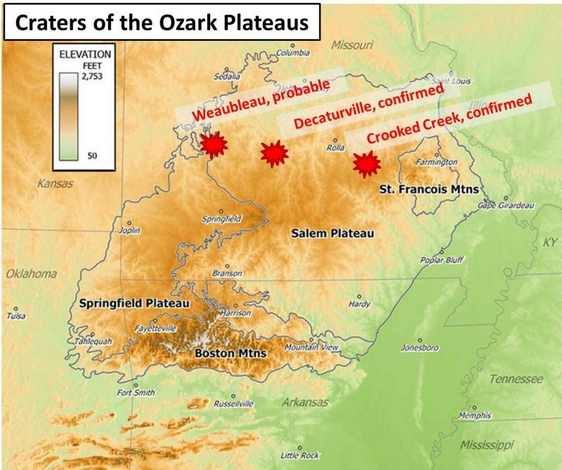 This image was constructed using a wikipedia public domain map as the background.
Substantial recent work on these structures has been done by, among others, Missouri State University. A number of field trip guides and various scholarly articles have also been published regarding these locations.
The 'Ozark Plateaus' is a geophysical region in the south-central United States that covers an area of about 50,000 square miles. It constitutes the land surface of most of the southern half of the state of Missouri, the northernwest portion of Arkansas, an area of northeastern Oklahoma, and a small portion of southeastern Kansas. The Ozark Plateaus region, commonly called the Ozarks, derives its name from the Springfield and Salem Plateaus that dominate most of the region. The area is bounded on the south, however, by the pinnacled remnants of a third, higher and younger, plateau that is today called the Boston Mountains. The northeastern portion of the region is characterized by exposed portions of Cambrian volcanic features and uplifted igneous basement rock known as the Ozark uplift in a general sense, and as the St. Francois mountains in its heavily weathered region of surface exposure.
To make sense of how the regional geochronological naming in the Ozark region relates to global geological time scales, I make frequent use of the GeoWhen database located at
Spencer C. G., 2011, Roadside Geology of Missouri, Mountain Press Publishing Company, Missoula, Montana.
A. G. Unklesbay, Jerry D. Vineyard (1992) Missouri Geology: Three Billion Years of Volcanoes, Seas, Sediments, and Erosion; University of Missouri Press.
Thompson, T.L., 1986, Paleozoic succession in Missouri, part 4Mississippian system: Missouri Department of Natural Resources, Division of Geology and Land Survey, Report of Investigations 40, part 4, 189 pp.
Middendorf, M. A., 2003, Geologic map of Missouri, sesquicentennial edition. Missouri Department of Natural Resources, Geological Survey and Resource Assessment Division, 1:500,000 scale wall map.